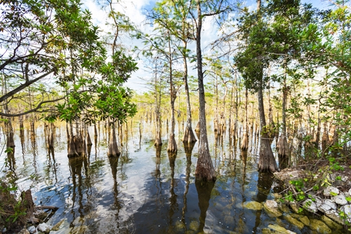
Wetlands will be mapped with the help of a terrestrial laser scanner
Land surveyors often use 3D laser scanning to collect accurate measurements of a property or external space. Laser scanners can be used for topography in other respects, however. An ecologist from Syracuse University has been able to use laser scanning technology to collect accurate data on various types of habitats to better understand wetland environments for the conservation of certain species of turtles and birds. From land surveying to research, 3D laser scanners are the tools professionals need to enhance the use of different natural spaces.
Laser scanners contribute to wetland preservation
According to Syracuse, two ecologists from the university are part of a team of interdisciplinary researchers interested in conserving natural environments – David Chandler, an associate professor of civil and environmental engineering, and Tom Langen, associate professor of biology. The team was given a two-year grant from the University of Michigan's Water Center to help two species flourish in preserved habitats. Chandler used part of his funding to use a terrestrial laser scanner to further this research.
With the help of some students, Chandler plans on using the laser scanner to map wetlands in order to gain information on their topography to determine if certain species of turtles and birds could successfully live in them. Using the laser scanners will allow Chandler to gain precise information about the existing conditions of each wetland and create digital images. These images can help Chandler better document the specifics of individual areas to understand their opportunities for habitation.
"It turns out that what's important to the turtles is having a wide range of puddles and pools that are good for basking and having baby turtles," Chandler said. "Warblers like certain types of tree and bush canopy to hide their chicks and easily get to a food source without predators."
Benefits of gathering topographical information
3D laser scanners have been used before to document wetlands. A team of researchers from Hungary and Austria used airborne laser scanning to gather information for vegetation mapping and monitoring, according to an article in MDPI. Streams specifically have been mapped by researchers for habitat monitoring and flood routing, as well as for engineers to gain information for major projects, such as dams and bridges, according to the Center for Watershed Studies at Virginia Tech.
Whether its for land surveying, research or engineering projects, 3D laser scanning is able to provide professionals with the accurate information they need to maintain and better utilize various environments.